


|
|
|
| Local Cycling Routes There are many cycling routes in and around Fortuna. Below is a list of currently approved routes: |
| • Corque Challenge Cup | ||||||||||||||||||
 |
||||||||||||||||||
| ||||||||||||||||||
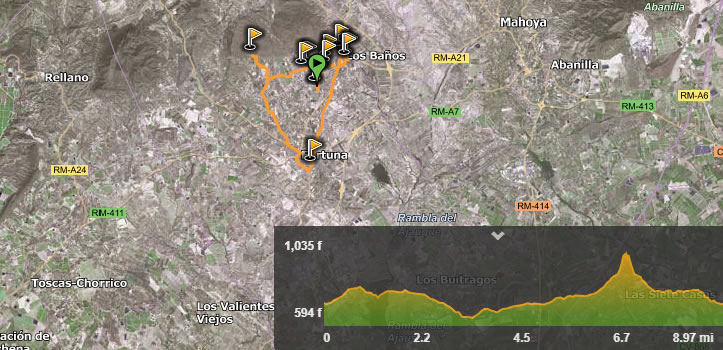
 This route is not too long but very steep in places, virtually impossible to ride, or is it. The Corque Challenge Cup has been designed to test even the hardened mountain biker. Register you want to enter the Challenge, set off from Camping Castillejo with a valid GPS and see how fast you can make it up and around the mountain and back to Camping Castillejo, the fastest times will be officially logged on the website and in due time we will have a race day to see who can win the Cup. This route is not too long but very steep in places, virtually impossible to ride, or is it. The Corque Challenge Cup has been designed to test even the hardened mountain biker. Register you want to enter the Challenge, set off from Camping Castillejo with a valid GPS and see how fast you can make it up and around the mountain and back to Camping Castillejo, the fastest times will be officially logged on the website and in due time we will have a race day to see who can win the Cup.The route leaves Camping Castillejo and works its way to the black Cave from there the cyclist climbs up a steep undulating track and then onto tarmac up to the water spring of St Geronimo. Taking a left turn off the main road the rider winds up to the base of the very very steep climb of the Sierra Del Corque, making this climb without getting off your bike will be an incredible feat. At the top the rider then follows the long downhill back to Fortuna and to finish at Camping Castillejo. Register your time and correct route with your GPS and you may be invited to the final where the top 5 in each category fight it out for The Corque Challenge Cup. Here are the simple categories: Mountain Bike Mens All Age Groups Womens All Age Groups E-Bike Mens All Age Groups Womens All Age Groups |
||||||||||||||||||
| • 14km Bańos Mountain Tour | ||||||||||||||||||
 |
||||||||||||||||||
| ||||||||||||||||||
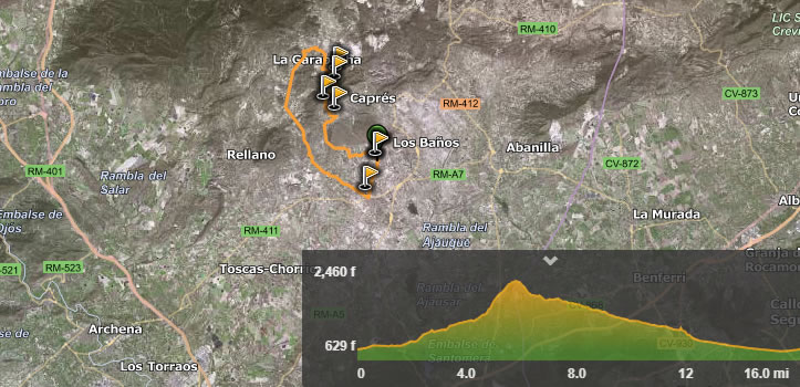
This route takes the rider from Camping El Castillejo to the the Bańos de Fortuna hot springs, passing by what was once an ancient Roman village, archeologists have discovered tombs full of weapons on this site and ancient pottery. Also, the large mound of earth on the left-hand side of the road was the village look out post and has to this day small pieces of roman pottery scattered around and on top of the site. You will also find just of the main road the original archeology excavations of the roman baths they have been studying this area for many years and have found numerous artifacts. Crossing the main road and heading to the modern-day Baths you will see the four-star Hotels that have therapeutic treatments available, the hot spring water is about 38 degrees and are said to have therapeutic healing capabilities. Heading out of Fortuna and then climbing the very steep hill to the village of Capres, this will be tough but much easier with the 500Wh Bosch battery, as you pass through the south side of the Sierra De La Pila National Park. You can fill up your water bottles at Saint Geronimo water point and then drop down the step hill heading back to Fortuna, be careful to follow your GPS as you are required to take a sharp left turn whist you are still on the hill. This track is tough but progressively down hill eventually you will arrive at the ancient Black Cave, archeologist discovered wall painting dating back to first century. Heading through the orange and lemon groves you will arrive at Las Calendas urbanization where there is a traditional Spanish bar and an Indian restaurant, you have only 1Km to go until arriving back at Camping Castillejo. |
||||||||||||||||||
| • 40km Monte Pila Circular Tour | ||||||||||||||||||
 |
||||||||||||||||||
| ||||||||||||||||||
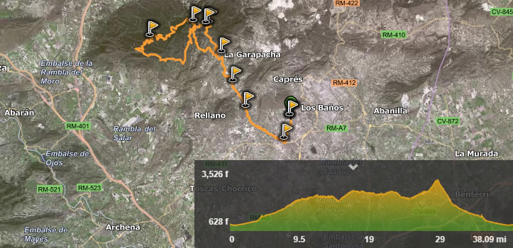
| 39.44km with 679m of elevation gain, this route is made for the intermediate rider. Leaving Camping Castillejo and passing around the Sierra de Los Banos and into the desert of Abanilla the rider feels like they are on the moon. The cyclist veers off the main road and up into the Sierras. Weaving their way up towards the peak of the Sierra De La Pila and towards Pena Zafa De Abajo past the marble mine. The route takes the rider below the peak of the Sierra De La Pila and on to the village of Garapacha. Here there is an old Church and bar next to it if you need refreshments. From here it’s a long downhill and not much time for sightseeing. Passing between the Sierra de Lugar and Cabezo de Satre at speed and passing through El Corteo de Las Penas. Once the down hill starts to level out you will pass through Las Calendas urbanization and past an Indian restaurant and a traditional Spanish Bar, just in case you need refreshments. Finally, you will arrive back at Camping Castillejo. |
||||||||||||||||||
| • Top of La Pila | ||||||||||||||||||
 |
||||||||||||||||||
| ||||||||||||||||||
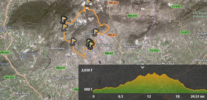
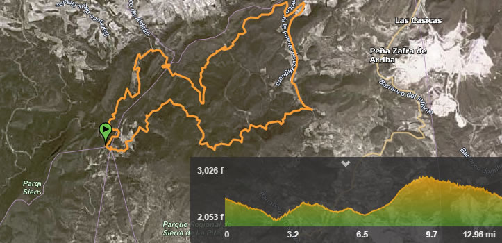
| 53.19km with 1465m of climb this is the classic route around the Sierra De La Pila. From Camping Castillejo the cyclist heads straight up the long climb to Garapacha village, passing through the historical site of El Corteo de Las Penas. This is a historic landmark and has some amazing natural rock formations. Many years ago, this route served as a strategic point to stop people passing from the south to the north and today is a protected area. Arriving at Garapacha and the old church the trail starts proper from here. Cycling through the sierra you will arraive at the ‘four Lane End’ meeting point and head East heading up to the peak. Shortly after this turning you will see the famous rock formation of the Sierra De La Pila.You will then take a sharp right turn and the final leg up to the peak. The cyclist will pass through the area of the Pozos De Nieve or snow Collecting Holes or Chambers, these were built to collect snow and save water when water was scarce. Then the climb increases until finally levelling out only to become very steep again as you approach the summit. The down hill is great and long so be careful, the track takes you a different way back on a winding track around the side of the mountain. The route back is fast and before you know it the cyclist is back in Fortuna and Camping Castillejo. |
||||||||||||||||||
| • Spa Baths, Fortuna and the Black Cave Trail | ||||||||||||||||||
 |
||||||||||||||||||
| ||||||||||||||||||
| This route takes the rider from Camping El Castillejo to the the Bańos de Fortuna hot springs, passing by what was once an ancient Roman village, archeologists have discovered tombs full of weapons on this site and ancient pottery. Also, the large mound of earth on the left-hand side of the road was the village look out post and has to this day small pieces of roman pottery scattered around and on top of the site. You will also find just of the main road the original archeology excavations of the roman baths they have been studying this area for many years and have found numerous artifacts. Crossing the main road and heading to the modern-day Baths you will see the four-star Hotels that have therapeutic treatments available, the hot spring water is about 38 degrees and are said to have therapeutic healing capabilities. The Trail then goes to Fortuna town and past the Boroque-style church and then on to the famous Black Cave, archeologists discovered painting on the walls dating back to the first century. Finally on the way back to Camping Castillejo if you are hungry or Fancy something to east you will pass an Indian restaurant and a traditional Spanish bar. |
||||||||||||||||||
| • Depths of the Sierra De La Pila | ||||||||||||||||||
 |
||||||||||||||||||
| ||||||||||||||||||
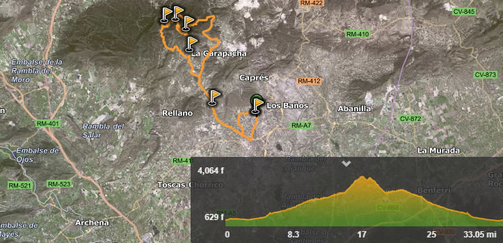
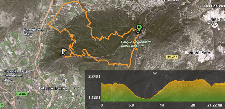
| 1639m of climb in 61.3km of track make this a challenging route. Leaving Camping Castillejo the cyclist passes briefly through Fortuna town and starts on the long climb up to the base of the Sierra De La Pila. Passing through El Corteo de Las Penas, this is a historic landmark and has some amazing natural rock formations. Many years ago, this route served as a strategic point to stop people passing from the south to the north and today is a protected area. You will then pass the small village of Casicas and on to Garapacha. The trail proper starts when you arrive at Garapacha, a quick look at the old church and the bar next to it, this will surely revive the cyclist and get them ready for the hard part of the trail to come. The trail takes the cyclist to the ‘Four Lane Ends’ meeting point and off to the west side of the Sierra De La Pila with beautiful views and winding tracks. Once back to the ‘Four Lane Ends’ meeting point the cyclist is off to the East side of the Sierra De La Pila. On the way round you will go up steep tracks and head towards the peak of the Sierra De La Pila. The steep climb will level out and you can see the Pozos De Nieve or snow Collecting Holes, these were built to collect snow and save water when water was scarce. Carrying on up the climb you will take a sharp right turn down a very technical track, be careful! This track will take you back to Garapacha and onto the long down hill back to Fortuna and Camping Castillejo. |
||||||||||||||||||
| • Inside Sierra De La Pila 1. | ||||||||||||||||||
 |
||||||||||||||||||
| ||||||||||||||||||
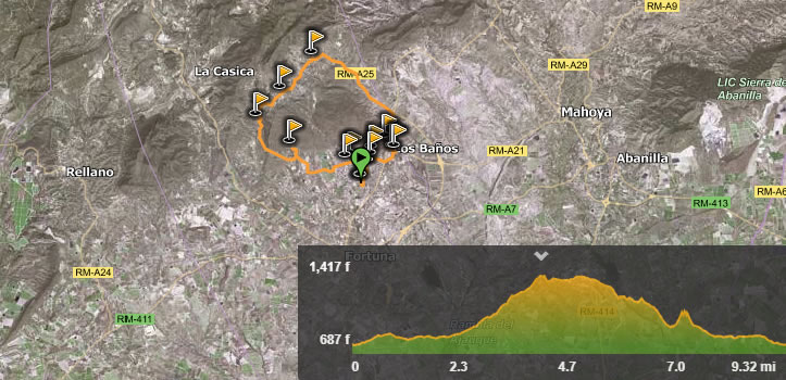
| Starting at the ‘Four Lane Ends’ meeting point the cyclist heads east on a trail that has rolling hills and some stunning views of the Sierra De La Pila. There is 614m of climb in only 20.85km making it also a challenge. |
||||||||||||||||||
| • Inside Sierra De La Pila 2 | ||||||||||||||||||
 |
||||||||||||||||||
| ||||||||||||||||||
| 43.8km of pure mountain track, starting at the ‘Four Lane Ends’ meeting point in the heart of the Sierra De La Pila. Heading west up and down the winding tracks into some of the most beautiful landscape views. This is a difficult route with 1155m of climb, ideal route to see parts of the Sierra De La Pila not often seen. |
||||||||||||||||||
 |
|
||||||||
 |

